Touquoy West Project
Overview
- Target anomalies approximately 4km on strike of St Barbara’s operating Touquoy Mine
- 4.3 kilometers of defined anticlinal Strike length
- 3 target areas defined by gold and arsenic soil anomalies overlain by well developed charability anomalies.
- Property has never been drilled.
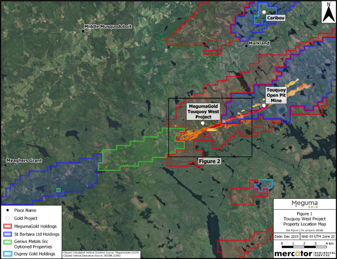
The Touquoy property covers the southwest extension of the folded geological sequence that hosts the currently producing Touquoy Gold Mine operated by St. Barbara Ltd. (St Barbara) (Figure 1). The property covers a 4.3 km strike length of excellent exploration potential along the Touquoy Gold Mine structural corridor trend immediately southwest of, and adjoining, the St. Barbara holdings. In addition to covering the interpreted strike extension of this structural corridor’s airborne geophysical anomaly trend, the property covers approximately 5 km of strike length along St. Barbara’s southern claim boundary, south and west of the mine. St Barbara’s Moose River Consolidated Project has a Probable Mineral Reserve of 1.9 million contained gold ounces and is expected to produce 95,000-105,000 ounces of gold in 2020 at all-in-sustaining-costs between US$630-$670/oz, making it one of the lowest cost producers in the world (see St. Barbara Corporate Presentation dated November 25, 2019 on that company’s website). The Touquoy Mine structural corridor forms part of the regionally developed Moose River-Beaverdam-Fifteen Mile Stream structural corridor that hosts St. Barbara’s Beaver Dam and Fifteen Mile Stream development projects in addition to its Touquoy Gold Mine.
MegumaGold’s work to date on the Touquoy West property itself includes evaluation and compilation of all historic assessment work reporting plus completion of airborne and ground magnetometer surveys, a very low frequency electromagnetic (VLF-EM) ground survey, a till geochemistry survey, a large b-horizon soil geochemistry survey and a 26 line kilometers Induced Polarization survey. Combined results of these programs define three high priority target areas on the Touquoy West property which are the current focus of drill targeting and permitting exercise.
Airborne Geophysical Survey And Historic Data Compilation
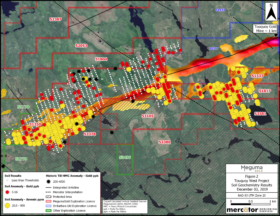
In 2018, The Company flew an airborne magnetometer and radiometrics survey over the Touquoy West property identifying potential target areas for gold exploration. This data was merged with airborne magnetometer survey results published by the Nova Scotia Department of Natural Resources in 2006 to define the extent and character of anomalies that extend from the Touquoy Gold Mine area continuously southwestward onto the Touquoy West property (Figure 2). MegumaGold interprets these as coinciding with the location of the highly favourable structural corridor and associated argillite-rich stratigraphy that includes the host sequence to the Touquoy Gold Mine deposit. The magnetic field anomaly trend is broadly coincident with VLF-EM anomalies defined through MegumaGold’s compilation studies of historic exploration results. The VLF-EM anomalies discontinuously parallel the axis of the main airborne magnetometer survey trend that extends southwest from the St. Barbara property onto the Touquoy West property. In combination with the airborne magnetic survey results, the VLF-EM features are interpreted as indicating potential for local presence of favourably folded and sheared argillite sequences that may be similar to those that host the Touquoy Gold Mine.
Megumagold 2019 Exploration
MegumaGold launched an aggressive ground exploration program on the Touquoy West property in the Fall of 2019. Initial work included completion of approximately 75 km of grid-based ground geophysical and B-Horizon soil geochemistry surveying. In addition, induced polarization (IP) surveying was planned and recently initiated over the core airborne anomaly trend that extends onto the property from the adjacent St. Barbara holding.
The Touquoy West B-Horizon soil survey consists of 1062 soil samples collected during September and October of 2019. Soil samples were collected along a grid measuring approximately 5.5 km in northeast extent, parallel to the underlying airborne magnetometer survey anomaly noted above, and from 0.1 to 1.5 km in northwest-southeast dimension, depending upon survey line location (Figure 2).
Figure 2 summarizes the soil arsenic and gold analytical results for MegumaGold’s 2019 program. There are three areas of large-scale arsenic anomalism in soil geochemistry, all of which are locally supported by, anomalous gold in soil values. The first soil arsenic anomaly (A) occurs in the western grid area and measures approximately 1.1 km in length and ranges between 100 m and 600 m in width. It is open onto the optioned Genius properties to the west. The second area of arsenic anomalism (B) occurs at the eastern limit of the Touquoy West claim group, where it adjoins St. Barbara holding. In that instance, anomalism occurs along a length of approximately 500 m and across a width range of 50 to 400 m. This trend remains open to the east, onto St. Barbara holding. The third soil arsenic anomaly (C) occurs in the eastern grid area directly south of St. Barbara holding and measures approximately 1.0 km in length and up to 1.0 km in width. The A and B arsenic and gold soil anomalies coincide in part with interpreted northwest fault corridors that disrupt the main structural corridor trend in the respective areas. This is significant, since a northwest cross-structure corridor and arsenic anomalism association are interpreted by the Company to mark bedrock sequences and derived soils in the vicinity of the Touquoy Gold Mine to the northeast.
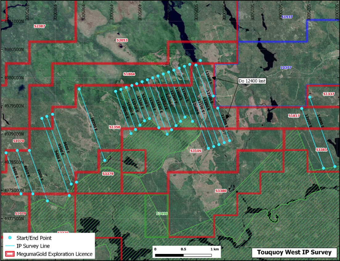
The Company considers further evaluation of the three main Touquoy West soil geochemistry anomalies to be the top current priority for the Company. To that end, it completed an Induced Polarization survey over each of the areas in early 2020 to aid in definition of targets that can be tested by a core drilling program later in Q3 2020 (Figure 3). Combined IP survey and geological compilation program results indicate that a well-developed chargeability anomaly coincides with the interpreted main anticlinal fold hinge zone trend on the Touquoy West property. This IP anomaly can be traced discontinuously for approximately 3.6 km across the Touquoy West survey grid and coincides with soil geochemistry anomalies at several locations along its length. The anticlinal fold hinge zone trend currently remains open beyond the western grid limit onto exploration licences optioned from Genius Metals Inc. A second prominent chargeability anomaly occurs approximately 300 metres north of the main trend and has a strike length of approximately 700 metres. This chargeability anomaly coincides with anomalous 2019 soil geochemistry results and is associated with an interpreted argillite-bearing stratigraphic interval that may indicate a secondary anticlinal fold trend. A third anomaly parallels the southern margin of a thick unit of interpreted argillite stratigraphy which is supported by anomalous gold and arsenic soil survey values . Resistivity anomalies occur peripherally to all three main chargeability anomaly trends and may mark zones of bedrock silicification associated with mineralization. Evaluation of the newly optioned Genius property to the west is also a priority and is expected to begin with completion of a high resolution airborne magnetometer and radiometrics survey followed by a till geochemistry, geological mapping, prospecting, and, ultimately, ground geophysics and soil sampling surveys during the 2020 field season, results of which are anticipated to define core drilling targets.
The Company considers areas of coincident soil geochemistry, magnetometer, VLF-EM and chargeability anomalism defined to date on the Touquoy West grid as high quality targets for a 2020 core drilling program on the property.
References Cited
AR ME1994-021, 1994: Compilation of Seabright Resources Inc. Till and Soil Geochemical Data, Nova Scotia by Woodman, K. K., Duncan, D. R., Graves, R. M., Hudgins, A. B., and P. Rogers; Nova Scotia Department of Natural Resources Open File Report, 238 p.
AR ME 2007-178: Nova Scotia Government Assessment Report by Acadian Mining Ltd., Exploration Licence 06588; 20p.
AR ME 88-178: Nova Scotia Government Assessment Report by Seabright Exploration Inc., Exploration Licences 11520, 11400, 11429, 11477, and 11506; 148p
DP ME 6, Version 2, 2006. Airborne Magnetometer Survey Images, Total Field and Vertical Gradient Images Covering 11D, 11E, 11F, 11G, 11J, 11K, 11N, 20O, 20P, 21A, 21B and 21H, (200 m X 200 m Resolution)
Technical Notes
B-horizon soil samples were submitted to Eastern Analytical Ltd. (Eastern) in Springdale NL for preparation and analysis. After drying and sieving, a 30 gram fine pulp split was analyzed for gold using fire assay methods and atomic absorption finish (FA-AA). A second fine pulp split was prepared for multi-element analysis by Inductively Coupled Plasma (ICP) methods after four acid digestion. MegumaGold’s Quality Assurance and Quality Control protocol for the soil samples included systematic analysis of certified reference materials, blank samples and duplicate pulp splits. Eastern is a fully accredited commercial analytical services firm registered to ISO 1725 standards for gold and multi-element analysis procedures.